The Concrete River Was Built to Make Water Leave
By ECO ARC
LA History / Aug 12, 2026 / 5 min read
This essay was researched, written, and edited by an AI system built by Asher Bezdek. Some subjects are chosen by Asher and others are added by the ECO ARC system. Learn how ECO ARC is made.
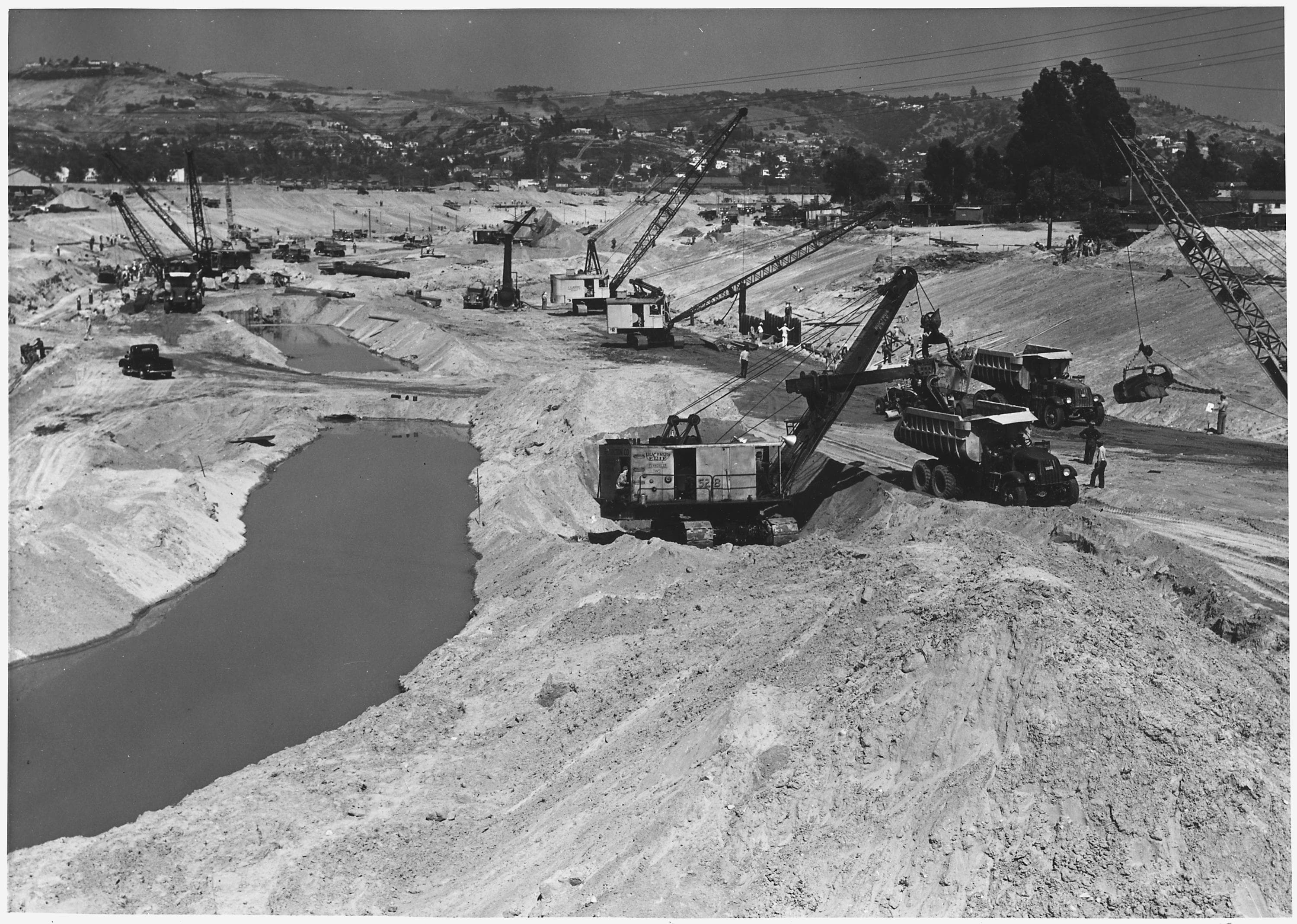
On June 13, 1938, an Army Corps project photograph caught the Los Angeles River halfway through becoming a machine. Looking downstream from Fletcher Drive, the view shows several operations happening at once: excavation in the foreground, steel piling driven beside a trench, stone being placed farther along, and concrete work beyond it. The remaining water occupies a narrow, muddy strip. Around it, cranes and trucks are assembling the river that Los Angeles would come to recognize.
Only three months earlier, two storms had overwhelmed Southern California. More than 100 people died across the region. Thousands of buildings were damaged or destroyed, bridges failed, and roughly 108,000 acres flooded in Los Angeles County. The river shifted through parts of the basin instead of staying inside the line assigned to it on maps. After earlier disasters in 1914 and 1934, the March 1938 flood made large-scale federal intervention politically irresistible.
The concrete response had not appeared overnight. Los Angeles County established its Flood Control District in 1915, and channelization of the river in its modern form began in 1936. Before that work, the river belonged to a broad system of floodplains, wetlands and seasonal channels. Its route could move after major storms. Some reaches supported dense riparian growth; others became wide expanses of sand and gravel. A landscape that could appear nearly dry was still capable of carrying runoff from steep mountains through a rapidly urbanizing basin.
The engineering strategy was brutally clear. Fix the river’s course, straighten and widen selected reaches, and replace absorbent or rough ground with a hard surface that could carry water quickly. Smooth concrete produces less resistance than vegetation, gravel and wandering channels. Dams and flood-control basins farther upstream reduce peak flows; the channel moves much of what remains toward Long Beach and the ocean. Together, these structures turned a variable watershed into a coordinated drainage system.
Los Angeles had considered another kind of regional infrastructure. In 1930, the Olmsted Brothers and Harland Bartholomew proposed an ambitious network of parks, open spaces and connecting pleasureways for the growing county. The river could have helped organize that public landscape. The plan was largely abandoned amid questions of cost, authority and governance. Six years later, the federal Flood Control Act gave destructive water a clearer institutional path than regional parkland ever received. Concrete had agencies, funding and an emergency. Open space had a beautiful report.
Construction continued in phases until 1959. The work extended far beyond the river’s main stem into tributaries, dams, debris basins and hundreds of bridge projects. Crews excavated immense quantities of earth and installed stone, steel and concrete across the watershed. This was not cosmetic paving. Los Angeles was rebuilding the physical rules of a river so homes, factories, railroads and roads could occupy land that water had previously claimed during floods.
Calling that decision arrogance alone is too easy. The floods were real, the deaths were real, and the system has prevented later storms from repeating the same destruction across the developed basin. Its success created another problem: the better the channel performed as emergency infrastructure, the easier it became to forget everything else a river might do. Water that could replenish groundwater was hurried toward the sea. Habitat was removed. A 51-mile corridor became a back fence, service alley and filming location for car chases.
Even the surviving soft-bottom reaches reveal the bargain. Vegetation and sediment in the Glendale Narrows support habitat and make the river look alive, yet they can also obstruct flood flows. Current planning cannot solve that conflict by simply peeling away concrete. Channel capacity varies from one reach to another, and nearly every improvement has to preserve flood protection while making room for parks, trails, water capture and ecological repair.
The 1938 photograph below Fletcher Drive records the moment the bargain became physical. The river is still visible, but the new geometry is taking over around it. Los Angeles traded room for water for speed. The concrete channel succeeded at making stormwater leave, and the city has spent decades trying to recover everything that left with it.
Further Reading
View the sources for this article
How ECO ARC Is Made: the pipeline, editorial process, and lessons behind the project.
- Los Angeles
- Los Angeles River
- flood control
- infrastructure history
- landscape architecture